Friday, September 3, 2010
Home September 2
We have had a wonderful 3 week journey through Arizona, Utah, Montana and Wyoming but as Dorothy says” there is no place like home”!
Monument Valley August 31


After breakfast at the San Juan Inn, we drove the 20 miles to Monument Valley with photo stops along the way. We were too early to check in so we drove the rough 17 mile drive through the valley. We had been here in the late 90’s but didn’t remember the terrible road. I wasn’t as impressed with the formations as I had anticipated probably because we have seen so much natural beauty on this trip. The condition of the road added to this feeling as we were bumped and jarred until I thought my teeth would fall out! Our van was coated with red dust. We were both grateful to be back on paved road again. We checked in to our hotel, The View Inn, early and I worked on photos and the blog. From the balcony in our room, we had amazing views of the mittens, the most famous of the formations in Monument Valley. I wanted to capture sunset and sunrise photos and the best came at pre sunrise. I even tried a night shot.
Mexican Hat August 30
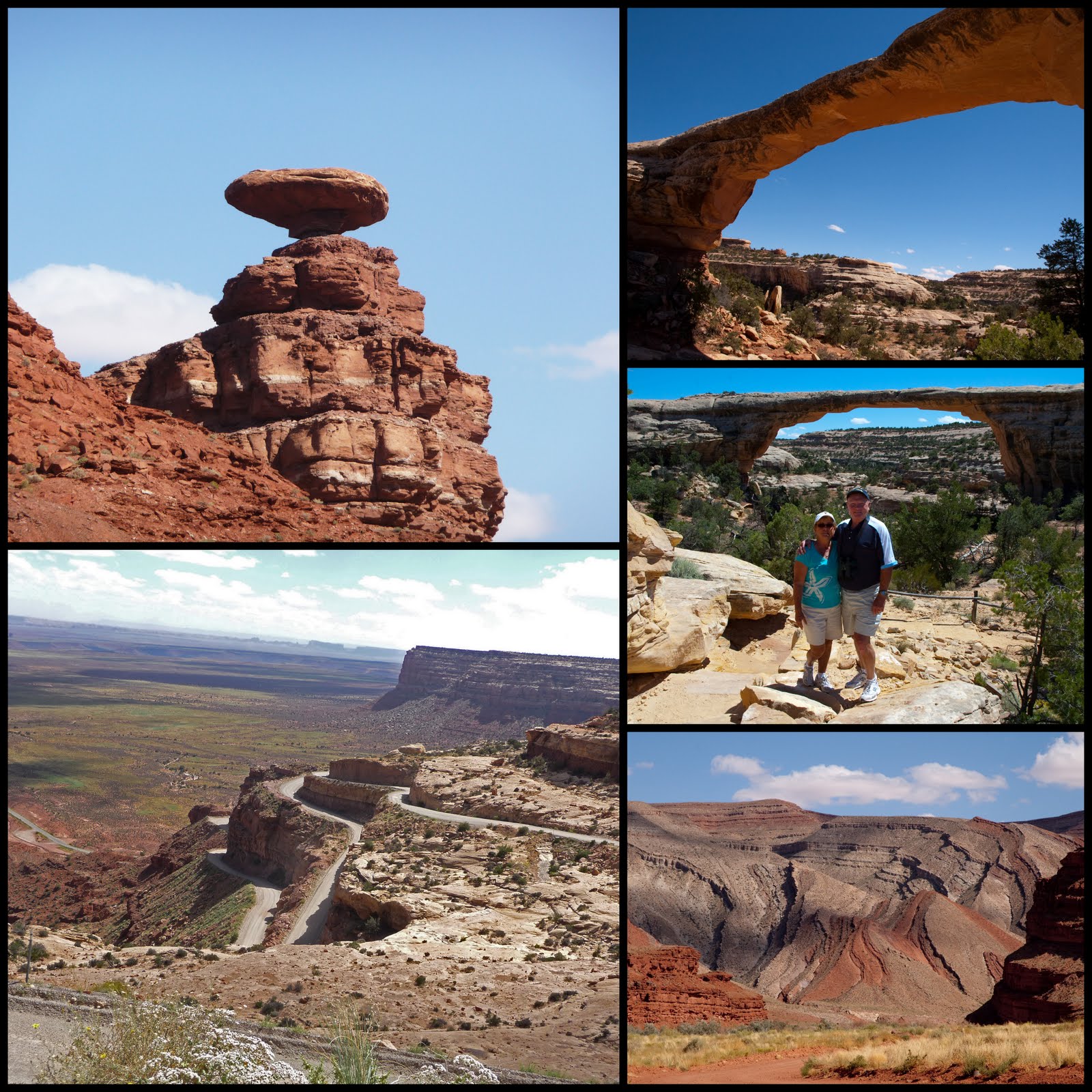

The Goosenecks

Newspaper Rock

Bob found some wonderful sights to see on our way to Mexican Hat today. One thing that I have forgotten to mention is the fields of wild sunflowers that we have been seeing since we left Yellowstone. We have been amazed at the abundance, especially in August. Our first stop was Newspaper Rock which was an even bigger petro glyph display than Rochester Rock and much easier to get to. After imagining what the artists were trying to say, we went on to Natural Bridges National Monument. We discovered that a natural bridge is formed by the erosive action of moving water and an arch is formed from frost and seeping water. The three bridges here were protected in 1908 by the establishment of Utah’s first National Park System area. We walked down to the bottom of Owachomo Bridge because it was the easiest hike. All of them are visible from overlooks but it is really cool to be able to stand under one of them. We then took a scenic short cut to Goosenecks State Park. The road turned to gravel and then we drove via switch backs one of the scariest roads ever for me. I took photos but they will never show what we experienced. The Goosenecks are an impressive example of an entrenched river meander as the San Juan River twists and turns for over six miles advancing only 1 ½ miles towards Lake Powell. We saw the rock that is the namesake for Mexican Hat and turned onto a dirt road to look for petrified wood as our host at the B&B heard that there was a possibility of finding some in the area. We didn’t find any but we enjoyed some beautiful views of unusual sedimentary layers. We checked into our funky hotel, The Hat Rock Inn and then had a fine dinner at the San Juan Inn.
Tuesday, August 31, 2010
Moab August 29

 Potash Pools
 Delicate Arch
We decided to splurge on a flight over the parks today. Our hosts at the B&B gave us a recommendation of Red Tail Aviation and we thought that Nick, the pilot, was great. We left the airport at 9:15 and flew over Arches first and saw the Delicate Arch and many of the arches that we had seen yesterday. We were glad that we did the flight after we had driven through the park so that we had a good feeling for the layout. It was windy and the flight was pretty bumpy. Every time I would take a shot, the camera would recoil and I felt like Dirty Harry. We then headed over to Canyonlands and it got bumpier! The views were magnificent and we especially enjoyed seeing the confluence of the Green and Colorado Rivers. The Green River is aptly named and the Colorado is brown. The line where they merged was so clear. The flight lasted an hour and we all felt the effects of the bumpy flight, even Nick. That was a fantastic way to see the parks!. Then back into Arches to see the double arch. We decided to make it a short day and went back to the B&B. On our way back we drove out to see some dinosaur tracks that were visible from the road.
Moab August 28
 Landscape Arch
Dead Horse Point

Canyonlands National Park


A storm was in the area this morning and it rained during our breakfast at the B&B. We decided to tour Canyonlands today since it is more of a driving park with overlooks. We went to Dead Horse Point State Park first and saw some beautiful views of the Colorado. We discovered that the reason that this area was not made a part of the national park is that it is being mined for potash. Water from the Colorado is pumped into 3000 foot wells to dissolve the minerals and then injected into flats, and then allowed to evaporate. The flats were kind of pretty but out of place in the environment. It was overcast but no rain so we went on to Canyonlands. While we were there, the sun came out and we had white puffy clouds. Canyonlands is Utah’s largest national park at 527 square miles and one of the newest; established in 1964. The canyon, created by the Colorado River is 1/2 the width and 1/2 the depth of the Grand Canyon so it is very impressive. We explored the section of the park called Island in the Sky which is the most accessible by car and stopped at the many view points.
Since the weather had turned in our favor, we decided to head over to Arches National Park. We walked out to Landscape Arch, the largest arch at 306’. An easy walk of 1.6 miles, there were two short side trips to two other arches along the way. We ended up in the Windows section for the sunset and views of North and South Window as well as Turret Arch. It was a long but fruitful day.
Since the weather had turned in our favor, we decided to head over to Arches National Park. We walked out to Landscape Arch, the largest arch at 306’. An easy walk of 1.6 miles, there were two short side trips to two other arches along the way. We ended up in the Windows section for the sunset and views of North and South Window as well as Turret Arch. It was a long but fruitful day.
San Rafael Country August 27


We drove from the Jackson Hole to Price, Utah yesterday which took 7 ½ hours. We stopped at the College of Eastern Utah Prehistoric Museum in Price on our way to the motel. As luck would have it, we had an hour to tour before closing at 6 pm. It had a fabulous collection of dinosaurs and fossils with great explanations. The visitor’s center for the area was in the lobby and a very knowledgeable woman gave us some interesting things to see on our way to Moab today. Our first stop was a one mile hike back to the Rochester Rock Art panel. This is the largest collection of petroglyphs on one rock we have ever seen and is considered one of the most unusual in Utah. Then we took the scenic Miller Canyon road to Interstate 70. The section of this interstate is probably the most beautiful in the entire US highway system. We traversed the San Rafael swell, a huge dome formed by pressure from under the earth leaving striking ridge-like formations sculpted by wind and water. The San Rafael Reef dominates the eastern side of the swell. The reef appears to be an impenetrable wall from the east and it was only in 1970 that the interstate was built through a pass in the reef. We had spectacular views the whole way!
The next stop was Goblin Valley State Park. As we drove in, we saw a small herd of prong horn sheep. We had a picnic lunch at the overlook and then walked down into the valley for a close up look at the stone gnomes. Actually, they look more like mushrooms and that was the name given to the valley by the discoverer. We needed to hurry as we could see a storm closing in. The wind came up on our way back and we were in the middle of a sand storm. We finally made it to the B&B that was to be our home for three days in Moab at 5:00.
The next stop was Goblin Valley State Park. As we drove in, we saw a small herd of prong horn sheep. We had a picnic lunch at the overlook and then walked down into the valley for a close up look at the stone gnomes. Actually, they look more like mushrooms and that was the name given to the valley by the discoverer. We needed to hurry as we could see a storm closing in. The wind came up on our way back and we were in the middle of a sand storm. We finally made it to the B&B that was to be our home for three days in Moab at 5:00.
Sunday, August 29, 2010
Grand Teton National Park August 25


We drove into the park today for views of the Tetons and of course, we had to have our photo taken at Jenny Lake. The visitor center in Moose is fantastic so we spent some time there enjoying the exhibits and the movie. Lunch was in Jackson Hole at a historic old hotel and then a walk around the town. There was a shop that was full of animal heads and hundreds of taxidermy animals! I had never seen anything like it before. Our lodge was elegant rustic and loaded with carved bears. This area really plays up the backwoods theme!
Subscribe to:
Comments (Atom)